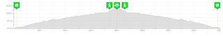
Let's suppose you recorded a track like this:
Note that the path is "broken" in 4 smaller parts. Those parts are called track segments. Every track can have multiple track segments and GPS devices will usually create a new segment every time it lost GPS satellite visibility (for example if you entered in a tunnel or a deep canyon) or you temporarily switched it off.
But we have another problem here. When we reached the peak the batteries of our GPS discharged and that's why we don't have the return of our trip recorded. BTW, the return was the same path.
This is a typical scenario where you would use the new "Track segment editor" on Trackprofiler. When you click on the "segment editor" tab you will see the map with numbered segments and on the right the list with all possible operations on single segments:

Use to join two segments.
Now back to our problematic track. We need to:
Note that the path is "broken" in 4 smaller parts. Those parts are called track segments. Every track can have multiple track segments and GPS devices will usually create a new segment every time it lost GPS satellite visibility (for example if you entered in a tunnel or a deep canyon) or you temporarily switched it off.
But we have another problem here. When we reached the peak the batteries of our GPS discharged and that's why we don't have the return of our trip recorded. BTW, the return was the same path.
This is a typical scenario where you would use the new "Track segment editor" on Trackprofiler. When you click on the "segment editor" tab you will see the map with numbered segments and on the right the list with all possible operations on single segments:

By selecting the drop-down with the number you can change the segment order in your GPS file. Use  to reverse the order of points inside that segment. With
  you can duplicate the segment or delete it with
  .
.
to reverse the order of points inside that segment. With you can duplicate the segment or delete it with .Use
to join two segments.Now back to our problematic track. We need to:
- Join all our segments using
- copy the resulting segment with
- reverse the points on the second segment (the returning path) with
- join them together with
...and the result will be the complete path without "holes":

The Track segment editor is online now.
Feedback is welcome!

