Sunday, 9 November 2014
Thursday, 6 November 2014
GPX 1.1 and track routes
The first version Trackprofiler worked with only one kind of GPS files -- GPX. Not even all versions of GPX, only 1.0. That wasn't a big problem since 1.1 wasn't used very much at the time. With time I added more formats, but as for GPX handling -- Trackprofiler remained for years with 1.0.
Part of this latest rewrite is the ability to handle GPX 1.1.
Related to GPX handling comes another feature. Track files can contain three different kinds of entities:
Related to GPX handling comes another feature. Track files can contain three different kinds of entities:
- Tracks (with segments)
- Routes
- Waypoints
Tracks are a series of geo-locations recorded with a real GPS. Routes are "planning stages" for tracks, they usually contain fewer points (per unit of distance) and are created by the user on the computer without the need of a GPS unit. Routes are usually uploaded to the GPS (not downloaded from like tracks) and are used to help people navigate outdoor.
Trackprofiler is a GPS track editor, but tracks and routes are basically similar, and that's why you can convert track to route on-the-fly when downloading. But there was one thing missing, you couldn't upload a track consisting of only routes.
Now you can, on the upload page there is a checkbox "Convert routes". If checked routes will be converted to tracks and then you can edit them as with any other track on Trackprofiler.
Wednesday, 5 November 2014
Track snapshots and multistep undo
...so, let us start with the changes introduced with yesterday upgrade. The first I want to highlight is the "Undo" link when you are editing the track:
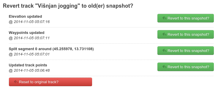
From now on, every change you make on a track is stored in a temporary memory with "snapshots" of the track. Snapshots are stored for 10-15 minutes from the moment you made the edit. When you are not happy with the changes you made -- you can reset the track to any of the snapshots (or, of course, reset it to original any time).
From now on, every change you make on a track is stored in a temporary memory with "snapshots" of the track. Snapshots are stored for 10-15 minutes from the moment you made the edit. When you are not happy with the changes you made -- you can reset the track to any of the snapshots (or, of course, reset it to original any time).
Tuesday, 4 November 2014
Faster Trackprofiler
After 4 weeks in beta testing the new version of Trackprofiler is deployed on the main site. This version brings many new features. I'll mention only one here (and leave the rest for another blogpost)...
In the last 3 months the entire code for GPX/track manipulation is rewritten from Python to Go(lang). The result is that all the track operations, graph and thumbnail reloading and map refresh time is now much faster than before.
More about this update soon...
In the last 3 months the entire code for GPX/track manipulation is rewritten from Python to Go(lang). The result is that all the track operations, graph and thumbnail reloading and map refresh time is now much faster than before.
More about this update soon...
Sunday, 11 May 2014
Private tags and edit quicklinks
A new version is just deployed with a bunch of new features.
First, you can now browse your own tracks by tags. When you visit your profile page you'll see your own tag cloud in the right column:

By clicking on any tag from the cloud, only your tracks tagged with that tag will be filtered. If you are careful to choose the right tags when uploading the track -- this is a good way to intuitively organize and quickly find tracks.
Next feature is track edit quick links. On any page where a list of tracks is shown, on your tracks you'll see edit icons/links:
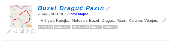
The title and description can be changed without moving from the page. The icons below the map thumbnail are quick links to the most used edit options.
And the last option... Premium users can now decide for uploaded tracks to be private by default. Just select the checkbox in your profile edit page.
Friday, 4 April 2014
Moving to Leaflet and Openstreetmap
Until a few weeks ago, all embedded maps on Trackprofiler were based on Google maps, but I've made a switch to Leaflet powered maps with MapBox powered layers based on Openstreetmap data and Bing maps layer for aerial imagery. The functionality is more-or-less the same as before.
Why the switch? Google maps is still a great solution which thought me a lot about mapping and online geographical programming, but there are some important reasons why I decided to rewrite a big part of Trackprofiler:
Why the switch? Google maps is still a great solution which thought me a lot about mapping and online geographical programming, but there are some important reasons why I decided to rewrite a big part of Trackprofiler:
- I believe that Openstreetmap is the future of mapping. It is a great community doing great efforts to create the best map data ever,
- Leaflet.js is a great mapping Javascript library, it is fast and easy to work with,
- Too restrictive terms of service,
- This allowed me to rewrite legacy parts of the application and this, in turn, will help to implement even more new features...
Saturday, 22 February 2014
More open source projects
Regular readers of this blog already know, Trackprofiler is not only built on open source components but is actively releasing new open source projects.
Continuing with this trend, here are two new projects for all users of the Leaflet.js mapping framework:
Continuing with this trend, here are two new projects for all users of the Leaflet.js mapping framework:
- Leaflet editable polyline: point-by-point editor for (very) big polylines
- Leaflet clicks: a small plugin for custom events where you need to differentiate between single and double clicks.
Saturday, 15 February 2014
Simplify GPS tracks
If you happen to record a GPS track driving on the North Dakota State Highway 46, which...
In that case you may use the new feature that is just deployed on Trackprofiler today. The "Simplify track" option will remove points where the track resembles a straight line. You can still decide how many points to choose (by selecting "More points" or "Less points" on the page).
Note that by removing intermediate points you remove the metadata, too. Most importantly the time (needed to compute the speed) and elevation. But, sometimes those are not that important and you need your tracks to contain only the shape of the path taken. If that's the case -- enjoy simplifying your tracks!
...is a 123 mile (198 km) road in eastern North Dakota, crossing the Red River Valley between Streeter and Oxbow. It parallels and runs about twenty miles (32 km) south of Interstate 94, and is the longest stretch of straight road in North America. (Wikipedia)...your track may have tens of thousands of points. Of course, since all of them present a straight line -- only two are important: The starting point and the ending point.
In that case you may use the new feature that is just deployed on Trackprofiler today. The "Simplify track" option will remove points where the track resembles a straight line. You can still decide how many points to choose (by selecting "More points" or "Less points" on the page).
Note that by removing intermediate points you remove the metadata, too. Most importantly the time (needed to compute the speed) and elevation. But, sometimes those are not that important and you need your tracks to contain only the shape of the path taken. If that's the case -- enjoy simplifying your tracks!
Sunday, 5 January 2014
Happy new 2014
Happy new 2014 year!
As you can see from posts on this blog -- 2013 was a busy year for Trackprofiler. This year will probably see some more features. In the last few weeks I was compiling a list of features from users, and here it is. This is what you can expect this year:
As you can see from posts on this blog -- 2013 was a busy year for Trackprofiler. This year will probably see some more features. In the last few weeks I was compiling a list of features from users, and here it is. This is what you can expect this year:
- Simplify tracks by removing too many points.
- OpenStreetMap and Leaflet integration instead of Google Maps.
- Easier handling of multiple tracks (bulk rename, change tags, delete, ...).
- Support for the newer GPX version of: GPX 1.1 (and possibly more track formats, as well).
- Show multiple tracks on one page.
- Multistep undo. At the moment the only way to revert an edit is to use "Revert to original track". With multistep undo You'll be able to undo only single edits.
- Login with Mozilla persona.
- Better editing tools for tags, automatic detection of tags.
- Share waypoints between multiple tracks.
- Public Trackprofiler API.
- Bulk download of tracks on Dropbox.
- User-defined colors for track segments.
- Microsites (more on this later...).
In italic are the features planned for the first 3-4 months of this year.
This is not a definitive list, maybe some new and important features will be added, but I hope that at least two-thirds of this list will be ready this year.
Thursday, 12 December 2013
Split and move GPS track segments
Some GPS devices record tracks with random errors like this:
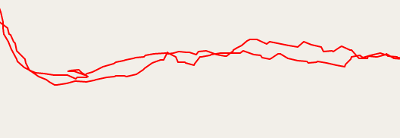
I followed a smooth path here, the actual GPS track looks pretty irregular. To fix it you need to move every point, or just use a real GPS (instead of a smartphone "GPS" :-).
Other times your track may look something like this:
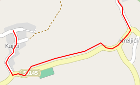
Note that the first part of the track follows the road but then it "decides" to leave the road (in reality, I never went off-road there) and then, later, it returns back on the road. To fix a problem like this one until now you had to use the "Edit points" option and move points one by one.
This is a problem people from CadenceVR had. For their product (a virtual reality cycling/training application), they need to have reliable tracks files. But when the GPS make an error like the above -- they need to fix many (thousands!) points by moving them one by one, and every move by the same few meters in the same direction.
After a few days of emailing back and forth with ideas on how to fix problems like this one, a new feature of Trackprofiler is born. You can now use the Segment editor to split segments and move them around:
How to do it...
I followed a smooth path here, the actual GPS track looks pretty irregular. To fix it you need to move every point, or just use a real GPS (instead of a smartphone "GPS" :-).
Other times your track may look something like this:
Note that the first part of the track follows the road but then it "decides" to leave the road (in reality, I never went off-road there) and then, later, it returns back on the road. To fix a problem like this one until now you had to use the "Edit points" option and move points one by one.
This is a problem people from CadenceVR had. For their product (a virtual reality cycling/training application), they need to have reliable tracks files. But when the GPS make an error like the above -- they need to fix many (thousands!) points by moving them one by one, and every move by the same few meters in the same direction.
After a few days of emailing back and forth with ideas on how to fix problems like this one, a new feature of Trackprofiler is born. You can now use the Segment editor to split segments and move them around:
How to do it...
- Click on the track to split the segment into two new (you can merge them back later)
- Drag the marker with the number at the start of the segment. The entire segment will move accordingly.
- When the segment is moved where it should have been you can merge the segments again.
Subscribe to:
Posts (Atom)
