Thursday 25 August 2011

Move GPS graph up/down

Last time in Ližnjan, we took a short walk. But, if you look closely at the resulting graph -- there is something wrong:


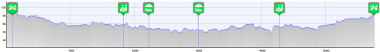
At the lowest point of our walk we were walking near the sea. So the lowest point should be zero. Instead, my Android phone measured the elevations completely wrong. In fact the entire track is 38 meters higher than it should be. I still don't know why, but sometimes smart phones get the GPS elevation completely wrong.

No problem, there is a new option to fix this. Just go to the "Elevation errors" tab, click on "Move graph up/down", and select the amount of vertical elevation change:


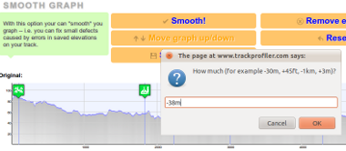
For example, I entered -38m (meaning: "Do move the entire graph 38 meters lower than now").
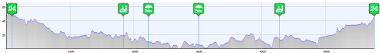
The result is:


PS. Thanks to Bill Casey for the suggestion!

Wednesday 24 August 2011

Upload GPS tracks by email

When mountaineering, I use my old Garmin GPS60. But, for short walks or bike trips, I record them on my Android with MyTracks app. A friend of mine asked me why I don't make an Android/iPhone app so that he would be able to upload tracks directly from his smartphone.

But working on two apps (iOS and Android) is a hassle. But, there is a solution! Even without the smartphone application! It is easy... Login on trackprofiler, go to  " Upload by email" tab. Copy-paste the email address from the page...


...in your favorite mail client. And voilà!

Next time outside, after you have recorder your track just send an email to this address. The email must have attached the GPX file with the track. The track will be parsed and uploaded directly to Trackprofiler.

Tuesday 23 August 2011

New icons

New version, lots of small bug fixes, one cosmetic change:

Icons before:


Icons now:


...and one important new feature: Upload tracks by email. More on this later.