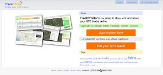
Just upgraded to a new version. You'll find out instantly that there is something new... The main page now looks like:
But the main difference is that now you don't need an account to upload, edit and share a GPS track. Just click on "Edit you track" and go... You can register later. You can merge this uploaded track with your existing account...
But you don't have to. It's up to you!
Tuesday, 12 July 2011
Tuesday, 5 July 2011
GPS track errors
Another small feature is rolled out; if your track has GPS measurement errors they may be elevation or latitude/longitude.
For elevations it was easy -- uplad your track, go to "Elevation smooth" tab, click "Remove extreemes" and voila -- all elevation errors are gone. But for position (i.e. latitude/longitude) there wasn't this option. At least till now.
And, by the way, the algorithm for GPS elevation errors detection is now much better.
For elevations it was easy -- uplad your track, go to "Elevation smooth" tab, click "Remove extreemes" and voila -- all elevation errors are gone. But for position (i.e. latitude/longitude) there wasn't this option. At least till now.
And, by the way, the algorithm for GPS elevation errors detection is now much better.
Tuesday, 21 June 2011
Lots of new stuff
Lots of new stuff last weeks. OK, mostly not so visible, but anyway...
New features:
New features:
- Now, if the image is GPS geocoded it will automatically be positioned on the map
- The elevation graph -- if you have too many elevation extremes (probably because of measurement error) now you can decide to delete them all at once. The app will proceed to find them all and remove them.
Minor bug fixes:
- If the waypoint was positioned near the end of the graph now it will be visible on the graph.
Comming soon:
- Upload/edit GPS track even without registration.
- Automatic detection of the points where you were stopped on the track and conversion of those points to waypoints.
Monday, 9 May 2011
Trackprofiler private beta to be launched
OK, I'm almost ready. Now, the list of editing options for tracks is:
- Join tracks,
- Split tracks,
- Move single points,
- Remove single points,
- Split track segments,
- Remove track segments,
- Smooth (i.e. remove GPS elevation errors),
- Add/edit/remove single waypoint,
- Remove all waypoints,
- Move entire track.
I completely changed the way how track editing (point by point) and track segment editing works. It should be easier now.
The last things before launching the private beta are in the process. Hope it will be ready during the next week. So, stay tuned ;)
Sunday, 13 March 2011
Image positioning
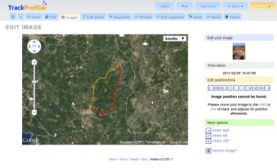
Image positioning on the track was one of the more problematic options of TrackProfiler. I say "was" because it should be way easier now. The new layout looks like:

If the image position can't be found -- the photo won't be shown on the map and You'll get a message about it.
And, by the way. Photos aren't correctly geopositioned when the camera time wasn't synchronized with the GPS time. When you upload and position your first photo -- TrackProfiler will memorize the "correction time" and all the following images on the same track should be OK.

If the image position can't be found -- the photo won't be shown on the map and You'll get a message about it.
And, by the way. Photos aren't correctly geopositioned when the camera time wasn't synchronized with the GPS time. When you upload and position your first photo -- TrackProfiler will memorize the "correction time" and all the following images on the same track should be OK.
Monday, 7 March 2011
Edit GPS track point by point
A quick screencast of the new "edit track point by point" feature on trackprofiler. Still not 100% complete (must make it faster), but it is usable:
PS. This is my first screencast, hope You like it.
Sunday, 13 February 2011
New layout for track pages
Just uploaded a new version. With some minor bug fixes the biggest change is a completely different layout of the GPS track page. Here's how it looked before:

...and here is the new version:

There are still a few quirks to be fixed, but the main layout is ready.
Hope You like it.

...and here is the new version:

There are still a few quirks to be fixed, but the main layout is ready.
Hope You like it.
Thursday, 20 January 2011
Moving/stopped GPS track stats
Just rolled out another small feature. Look at the stats column right of the map for your GPS track:

The new fields are:

The new fields are:
- Time stopped,
- Total time ( = time moving + time stopped ),
- Total speed ( = speed for entire duration of the track, including stopped time ),
- Time moving.
Sunday, 16 January 2011
Tag cloud
Another small feature added. Trackprofiler now has a "tag cloud" page:

...at the moment the biggest tags are members of my family :) but I expect they will become smaller as more people will register and upload their tracks.

...at the moment the biggest tags are members of my family :) but I expect they will become smaller as more people will register and upload their tracks.
Friday, 14 January 2011
Reset GPS track
Now that Trackprofiler has many ways of editing the track (images, waypoints, smoothing, joining segments, deleting segments, change segments order, moving track) -- it may happen that you make an error. What then? Till now -- you had to delete the track, upload a new (same) one and do all your changes once again (but without the erroneous one, of course ;).
Now, there is a new option -- "Reset track". By reseting the track it will return to its original file -- the one you uploaded without other changes you made. Check the "Reset" tab on the track page (after you sign on)...

PS. Images will survive the "reset" process.
Now, there is a new option -- "Reset track". By reseting the track it will return to its original file -- the one you uploaded without other changes you made. Check the "Reset" tab on the track page (after you sign on)...

PS. Images will survive the "reset" process.
Subscribe to:
Posts (Atom)