Just rolled out a new update with a an important improvement. The problem was that the track page was generated entirely at the moment you requested it (i.e. you clicked on the link). This is a somewhat slowish process and consequently the page load speed was also slow.
Now parts of the page are cached and the page load speed is improved by 3-4 times.
Enjoy!
Wednesday, 8 August 2012

Sunday, 22 July 2012
Embeding tracks
This month -- embeding GPS tracks from Trackprofiler in your site. It's easy -- when on the page with your track, just click the "Embed" tab. Then, copy the code on your page. There are 3 predefined widths for widgets, select the one that best fits in your page.
Here is an example of how it looks:
Here is an example of how it looks:
Thursday, 7 June 2012
Export track stats to a CSV file
In the last two weeks I was hiking around my small city (Višnjan). I made a total of 737.96564616 meters uphill, 32575.07452042m long (32680.59386254m if counting elevation).
How do I know those numbers?
Because there is a new option in TrackProfiler -- You can export track statistics in a CSV file. For all files or for files with specific tags. All I did was to export in CSV files with tags "visnjan" and "hiking" and then computing the sum of columns with Excel.
If you tag all your hiking tracks with "hiking", tracks when you were in Italia with "italy" and Alps tracks with "alps" -- just enter "hiking italy alps" in the new CSV exporter form. The resulting file will contain data for all those tracks.
How do I know those numbers?
Because there is a new option in TrackProfiler -- You can export track statistics in a CSV file. For all files or for files with specific tags. All I did was to export in CSV files with tags "visnjan" and "hiking" and then computing the sum of columns with Excel.
If you tag all your hiking tracks with "hiking", tracks when you were in Italia with "italy" and Alps tracks with "alps" -- just enter "hiking italy alps" in the new CSV exporter form. The resulting file will contain data for all those tracks.
Tuesday, 22 May 2012
Track analytics graphs
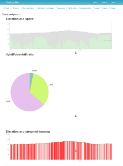
With a new version -- one new feature. Graphs for every track uploaded. At the moment, there are three kind of graphs:
- Graph with elevation and speed,
- Uphill/downhill ratio,
- Elevation and steepness heatmap.
I'll probably add more in the future.
PS. The library used or generating the graphs is now open source: see cartesius on github.
PS. The library used or generating the graphs is now open source: see cartesius on github.
Sunday, 8 January 2012
Tuesday, 6 December 2011
Redesign
I'm preparing a complete redesign of the site. Here's how it looks now:

...and here how it will look in a few days:

...and here how it will look in a few days:
Monday, 21 November 2011
Online GPS Route Editor [screencast]
What's the difference between "GPS Route" and "GPS Track"?
- A track is a collection of points of a path you actually made in real life. Track points contain GPS coordinates, time when it is recorder, the elevation of the point, ...
- A route is a collection of points of a path you didn't made in real lif, but plan to. Route points don't contain elevation and time. Routes usually contain less points than tracks but may be helpful when you organize your future outdoor activities.
Now, Trackprofiler has a new option to create, edit and organize routes. You can see here a quick screencast on how it works:
Tuesday, 8 November 2011
Announcement: Route editor
An early screenshot of the new feature; route editor:

+ edit routes based on one or more (multi-layered) tracks.
Later this month.
+ edit routes based on one or more (multi-layered) tracks.
Later this month.
Monday, 10 October 2011
Metric or US system for GPS track data
This month -- the option to switch from the metrics system (meters, kilometers, ...) to the US customary system (miles, feets) for every track. Just go on any track, select "Units" (top right) and select the system you want.
Alternatively, edit your profile and (un)check the "Use US/UK metrics (miles, feets, ...) when displaying track data" checkbox.


Alternatively, edit your profile and (un)check the "Use US/UK metrics (miles, feets, ...) when displaying track data" checkbox.
Thursday, 15 September 2011
Next-previous point
When you to edit the location on the track, now there are two new options that allow to more accurately choose the point. Till now you had to click near the track and hope that you clicked near the right point (in fact -- the nearest point will be selected).
Now, after you selected the location, you can move to next or previous point on the track, and then edit it as you want:

Now, after you selected the location, you can move to next or previous point on the track, and then edit it as you want:
Subscribe to:
Posts (Atom)
