Thursday, 25 August 2011

Move GPS graph up/down

Last time in Ližnjan, we took a short walk. But, if you look closely at the resulting graph -- there is something wrong:


At the lowest point of our walk we were walking near the sea. So the lowest point should be zero. Instead, my Android phone measured the elevations completely wrong. In fact the entire track is 38 meters higher than it should be. I still don't know why, but sometimes smart phones get the GPS elevation completely wrong.

No problem, there is a new option to fix this. Just go to the "Elevation errors" tab, click on "Move graph up/down", and select the amount of vertical elevation change:
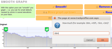

For example, I entered -38m (meaning: "Do move the entire graph 38 meters lower than now").

The result is:


PS. Thanks to Bill Casey for the suggestion!

Wednesday, 24 August 2011

Upload GPS tracks by email

When mountaineering, I use my old Garmin GPS60. But, for short walks or bike trips, I record them on my Android with MyTracks app. A friend of mine asked me why I don't make an Android/iPhone app so that he would be able to upload tracks directly from his smartphone.

But working on two apps (iOS and Android) is a hassle. But, there is a solution! Even without the smartphone application! It is easy... Login on trackprofiler, go to  " Upload by email" tab. Copy-paste the email address from the page...


...in your favorite mail client. And voilà!

Next time outside, after you have recorder your track just send an email to this address. The email must have attached the GPX file with the track. The track will be parsed and uploaded directly to Trackprofiler.

Tuesday, 23 August 2011

New icons

New version, lots of small bug fixes, one cosmetic change:

Icons before:


Icons now:


...and one important new feature: Upload tracks by email. More on this later.

Tuesday, 12 July 2011

Edit and upload track without registration

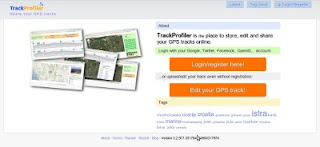
Just upgraded to a new version. You'll find out instantly that there is something new... The main page now looks like:


But the main difference is that now you don't need an account to upload, edit and share a GPS track. Just click on "Edit you track" and go... You can register later. You can merge this uploaded track with your existing account...

But you don't have to. It's up to you!

Tuesday, 5 July 2011

GPS track errors

Another small feature is rolled out; if your track has GPS measurement errors they may be elevation or latitude/longitude.

For elevations it was easy -- uplad your track, go to "Elevation smooth" tab, click "Remove extreemes" and voila -- all elevation errors are gone. But for position (i.e. latitude/longitude) there wasn't this option. At least till now.

And, by the way, the algorithm for GPS elevation errors detection is now much better.

Tuesday, 21 June 2011

Lots of new stuff

Lots of new stuff last weeks. OK, mostly not so visible, but anyway...

New features:
  • Now, if the image is GPS geocoded it will automatically be positioned on the map
  • The elevation graph -- if you have too many elevation extremes (probably because of measurement error) now you can decide to delete them all at once. The app will proceed to find them all and remove them. 
Minor bug fixes:
  • If the waypoint was positioned near the end of the graph now it will be visible on the graph.
Comming soon:
  • Upload/edit GPS track even without registration.
  • Automatic detection of the points where you were stopped on the track and conversion of those points to waypoints.

Monday, 9 May 2011

Trackprofiler private beta to be launched

OK, I'm almost ready. Now, the list of editing options for tracks is:

  • Join tracks,
  • Split tracks,
  • Move single points,
  • Remove single points,
  • Split track segments,
  • Remove track segments,
  • Smooth (i.e. remove GPS elevation errors),
  • Add/edit/remove single waypoint,
  • Remove all waypoints,
  • Move entire track.
I completely changed the way how track editing (point by point) and track segment editing works. It should be easier now. 

The last things before launching the private beta are in the process. Hope it will be ready during the next week. So, stay tuned ;)

Sunday, 13 March 2011

Image positioning

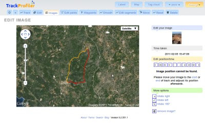
Image positioning on the track was one of the more problematic options of TrackProfiler. I say "was" because it should be way easier now. The new layout looks like:


If the image position can't be found -- the photo won't be shown on the map and You'll get a message about it.

And, by the way. Photos aren't correctly geopositioned when the camera time wasn't synchronized with the GPS time. When you upload and position your first photo -- TrackProfiler will memorize the "correction time" and all the following images on the same track should be OK.

Monday, 7 March 2011

Edit GPS track point by point

A quick screencast of the new "edit track point by point" feature on trackprofiler. Still not 100% complete (must make it faster), but it is usable:


PS. This is my first screencast, hope You like it.

Sunday, 13 February 2011

New layout for track pages

Just uploaded a new version. With some minor bug fixes the biggest change is a completely different layout of the GPS track page. Here's how it looked before:


...and here is the new version:


There are still a few quirks to be fixed, but the main layout is ready.

Hope You like it.