Sunday, 8 January 2012

Tuesday, 6 December 2011
Redesign
I'm preparing a complete redesign of the site. Here's how it looks now:

...and here how it will look in a few days:

...and here how it will look in a few days:
Monday, 21 November 2011
Online GPS Route Editor [screencast]
What's the difference between "GPS Route" and "GPS Track"?
- A track is a collection of points of a path you actually made in real life. Track points contain GPS coordinates, time when it is recorder, the elevation of the point, ...
- A route is a collection of points of a path you didn't made in real lif, but plan to. Route points don't contain elevation and time. Routes usually contain less points than tracks but may be helpful when you organize your future outdoor activities.
Now, Trackprofiler has a new option to create, edit and organize routes. You can see here a quick screencast on how it works:
Tuesday, 8 November 2011
Announcement: Route editor
An early screenshot of the new feature; route editor:

+ edit routes based on one or more (multi-layered) tracks.
Later this month.
+ edit routes based on one or more (multi-layered) tracks.
Later this month.
Monday, 10 October 2011
Metric or US system for GPS track data
This month -- the option to switch from the metrics system (meters, kilometers, ...) to the US customary system (miles, feets) for every track. Just go on any track, select "Units" (top right) and select the system you want.
Alternatively, edit your profile and (un)check the "Use US/UK metrics (miles, feets, ...) when displaying track data" checkbox.


Alternatively, edit your profile and (un)check the "Use US/UK metrics (miles, feets, ...) when displaying track data" checkbox.
Thursday, 15 September 2011
Next-previous point
When you to edit the location on the track, now there are two new options that allow to more accurately choose the point. Till now you had to click near the track and hope that you clicked near the right point (in fact -- the nearest point will be selected).
Now, after you selected the location, you can move to next or previous point on the track, and then edit it as you want:

Now, after you selected the location, you can move to next or previous point on the track, and then edit it as you want:
Thursday, 1 September 2011
Better search
Little by little, I'm uploading my entire archive of GPS tracks on TrackProfiler. But, as the collection grows, searching all tracks became harder. But, with the new search option is now much easier:

When you are logged on the site, you can decide if to search your own (public and draft) tracks or only public ones.

When you are logged on the site, you can decide if to search your own (public and draft) tracks or only public ones.
Thursday, 25 August 2011
Move GPS graph up/down
Last time in Ližnjan, we took a short walk. But, if you look closely at the resulting graph -- there is something wrong:

At the lowest point of our walk we were walking near the sea. So the lowest point should be zero. Instead, my Android phone measured the elevations completely wrong. In fact the entire track is 38 meters higher than it should be. I still don't know why, but sometimes smart phones get the GPS elevation completely wrong.
No problem, there is a new option to fix this. Just go to the "Elevation errors" tab, click on "Move graph up/down", and select the amount of vertical elevation change:
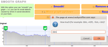
For example, I entered -38m (meaning: "Do move the entire graph 38 meters lower than now").
The result is:

PS. Thanks to Bill Casey for the suggestion!
At the lowest point of our walk we were walking near the sea. So the lowest point should be zero. Instead, my Android phone measured the elevations completely wrong. In fact the entire track is 38 meters higher than it should be. I still don't know why, but sometimes smart phones get the GPS elevation completely wrong.
No problem, there is a new option to fix this. Just go to the "Elevation errors" tab, click on "Move graph up/down", and select the amount of vertical elevation change:
For example, I entered -38m (meaning: "Do move the entire graph 38 meters lower than now").
The result is:
PS. Thanks to Bill Casey for the suggestion!
Wednesday, 24 August 2011
Upload GPS tracks by email
When mountaineering, I use my old Garmin GPS60. But, for short walks or bike trips, I record them on my Android with MyTracks app. A friend of mine asked me why I don't make an Android/iPhone app so that he would be able to upload tracks directly from his smartphone.
But working on two apps (iOS and Android) is a hassle. But, there is a solution! Even without the smartphone application! It is easy... Login on trackprofiler, go to " Upload by email" tab. Copy-paste the email address from the page...

...in your favorite mail client. And voilà!
Next time outside, after you have recorder your track just send an email to this address. The email must have attached the GPX file with the track. The track will be parsed and uploaded directly to Trackprofiler.
But working on two apps (iOS and Android) is a hassle. But, there is a solution! Even without the smartphone application! It is easy... Login on trackprofiler, go to "
Upload by email" tab. Copy-paste the email address from the page......in your favorite mail client. And voilà!
Next time outside, after you have recorder your track just send an email to this address. The email must have attached the GPX file with the track. The track will be parsed and uploaded directly to Trackprofiler.
Tuesday, 23 August 2011
New icons
New version, lots of small bug fixes, one cosmetic change:


...and one important new feature: Upload tracks by email. More on this later.
Icons before:
Icons now:
...and one important new feature: Upload tracks by email. More on this later.
Subscribe to:
Posts (Atom)
